 |
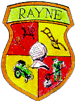
RAYNE Twinning AssociationTwinned with VERBERIE, FranceOLD RAYNE |
 |
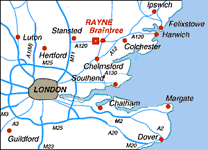
Rayne is about 40 miles [65km] north east of London in the County of Essex, which coincidently is twinned with Picardie in France. Although about the same size as Rayne in terms of population, Rayne villagers being so close to the town of Braintree, make use of the shops, schools and amenities provided there. Verberie on the other hand, is more self contained and has the appearance of a small town and the facilities to match.
Three Old Postcards - click to enlarge | ||
;) |
Junction of Rayne and Shalford Roads before 1920 Swan Inn on the right. |
|
| Hawkes shop to the left of the picture c1907, which has changed hands and uses many times over the last century, now it is an Indian restaurant. |
;) | |
;) |
The Cherry Tree Inn on the right c1907 has been known as the Welsh Princess for some years. The Foundry is in the middle of the picture. | |
There are several possibilities for the derivations of the name of our village:
- From an old Saxon word "hraegene" - meaning "shelter, hut, eminence"
- From "Regen", an old word meaning "river" which would explain "Raines Parva" being the little river (Pods Brook) and "Raines Magna" (Braintree), being the River Brain.
- From Roger de Ramis or Raimes, the Domesday lord of the manor.
Following the Roman invasion the road through the village developed great importance as it linked Camulodonum (Colchester), the first Roman capital of England, and Verulanium (St Albans). The road still bears its Roman name of Stane Street (although it is now known as The Street - the B1256). It is possible that Rayne was a resting place for legionaries and other travellers en route between Colchester and London or St Albans.
Our first detailed history comes from the Domesday Record of 1087. At the time of the Norman Conquest Rayne and Braintree were joined together to form the Lordship of Raines. The Manor of Rayne Hall amounted to about 260 acres; before the Conquest there were 18 villeins and 7 ploughs, but after the Conquest there were only 5 villeins and 2½ ploughs (i.e. one was shared). The Domesday Book shows that sheep were the main livestock of the Manor of Rayne.
In 1199 Braintree was granted its market charter by King John and thus separated from Rayne.
Life in Rayne during the 16th century centred around the village's 3 manor houses - Old Hall (Barnard's), Rayne Hall and Haverings. These estates provided most of the employment for the men on the land and for some of the women in the houses. The majority of villagers lived in small crofts owned by their employers - they grew their own crops and some of the women and children would have increased their income by weaving. During the 16th century several large houses were built by local tradesmen and a number of these can still be seen in The Street.
At the time of the Great Plague in 1666, because of its remoteness and scattered population, Rayne escaped the worst of the plagues as out of the 300 inhabitants at that time only about a dozen were affected.
During the 18th century there was a considerable range of handicrafts and small rural industries within the village. Records show a wheelwright, a builder, carpenters, a tailor, a shoemaker, a glover, a cooper, a "paylemaker", a pattern-board maker, a saddler, a baker and a butcher. The Maltings was in business throughout the century, as was Rayne Water Mill. Almost all the women and girls in the village did some spinning.
The Industrial Revolution of the 19th century scarcely affected the life of Rayne with the railway, opened in 1869, and Rayne Foundry the only obviously visual impacts. With the decline of the Essex woollen cloth trade, farm workers' daughters, who had once spun cloth, could now enter the new Braintree silk factories. The 1871 census shows the village as it was just before the decline in agricultural employment and the handicrafts. The 7 chief farmers employed 133 farm workers.
The village had 2 inns, The Swan and The Cherry Tree, and a beer house. Several shops had now appeared on The Street and some of the men worked in Rayne Foundry. In 1865 20 - 30 labourers from Rayne emigrated to America, Canada and Australia and by the end of the century most of the yeoman farmers had left Rayne, many of them emigrating.
The opening of the 20th century saw Rayne a quiet rural village of about 100 houses. Up to the present day most of the land within the Rayne boundaries has been developed and used for agriculture. The hop fields disappeared in the 19th century and by the middle of the 20th century the orchards had also disappeared.
During the 1939 - 1945 war most of the grazing land was ploughed up and mixed arable farming became dominant. The postwar scene followed this pattern with the growing of potatos, sugar beet, field beans for fodder, and seed crops. By 1975 the one remaining dairy herd had been sold.
The production of eggs, egg hatching and broiler production occupied an important place in farming towards the end of the 20th century but by the turn of the century a number of farm buildings had been converted into industrial units.
 If you would like more information Old Verberie Modern Rayne If you would like more information Old Verberie Modern Raynethen please email :- |
 Return to Twinning Homepage Return to Twinning Homepage | |
| Twinning@Rayne-info.org.uk | © Geoffrey Stone, Braintree 9-1-2004 Last update 18-1-08 | |